Thursday, June 25, 2015

Sagarmatha National Park

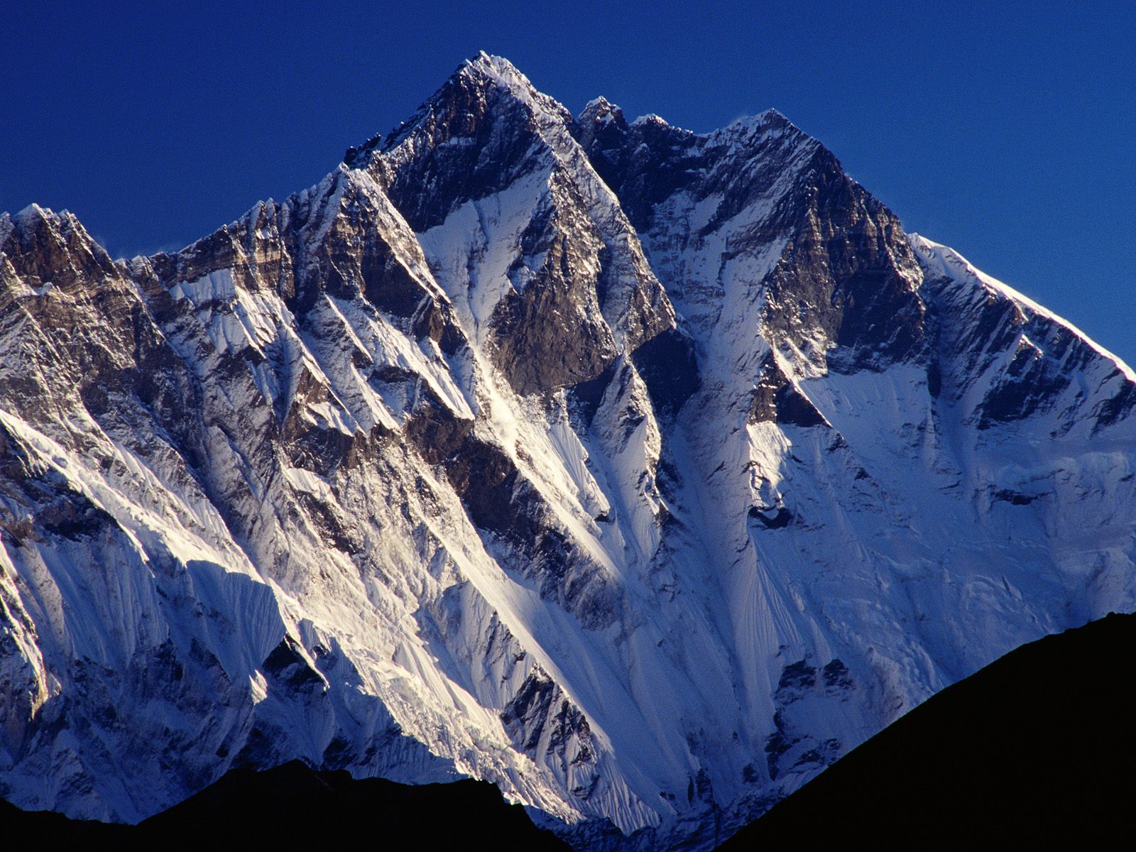
The Sagarmāthā National Park (sagaramāthā rāṣṭriya nikuñja) is a protected area in the Himalayas of eastern Nepal that is dominated by Mount Everest. It encompasses an area of 1,148 km2 (443 sq mi) in the Solukhumbu District and ranges in elevation from 2,845 m (9,334 ft) to 8,848 m (29,029 ft) at the summit of Mount Everest. In the north, it shares the international border with the Qomolangma National Nature Preserve of Tibet and extends to the Dudh Kosi river in the south. Adjacent to the east is the Makalu Barun National Park.
Sagarmāthā is a Nepali word derived from सगर् sagar meaning "sky" and माथा māthā meaning "head".
The protected area has been identified as an Important Bird Area by BirdLife International and is included in the Sacred Himalayan Landscape.

History

The Sagarmatha National Park was established in 1976. In 1979, it became the country's first national park that was inscribed as a Natural World Heritage Site. In January 2002, a Buffer Zone comprising 275 km2 (106 sq mi) was added. Under the Buffer Zone Management Guidelines the conservation of forests, wildlife and cultural resources received top priority, followed by conservation of other natural resources and development of alternative energy.
Tourism to the area began in the early 1960s. In 2003, about 19,000 tourists arrived. About 3500 Sherpa people live in villages and seasonal settlements situated along the main tourist trails. The park's visitor centre is located at the top of a hill in Namche Bazaar, where a company of the Nepalese Army is stationed for protection of the park. The park's southern entrance is a few hundred metres north of Monzo at 2,835 m (9,301 ft), a one day trek from Lukla.


Annapurna

Annapurna (SanskritNepaliNewar: अन्नपूर्णा) is a massif in the Himalayas in north-central Nepal that includes one peak over 8,000 metres (26,000 ft), thirteen peaks over 7,000 metres (23,000 ft), and sixteen more over 6,000 metres (20,000 ft). The massif is 55 kilometres (34 mi) long, and is bounded by the Kali Gandaki Gorge on the west, the Marshyangdi River on the north and east, and by Pokhara Valley on the south. At the western end the massif encloses a high basin called the Annapurna SanctuaryAnnapurna I is the tenth highest mountain in the world at 8,091 metres (26,545 ft) above sea level.

The entire massif and surrounding area are protected within the 7,629 square kilometres (2,946 sq mi) Annapurna Conservation Area, the first and largest conservation area in Nepal. The Annapurna Conservation Area is home to several world-class treks, including the Annapurna Circuit.

Annapurna is a Sanskrit name which literally means "full of food", but is normally translated as Goddess of the Harvests. According to Devdutt PattanaikAnnapoorna devi is "... the universal and timeless kitchen-goddess ... the mother who feeds. Without her there is starvation, a universal fear: This makes Annapurna a universal goddess ... Her most popular shrine is located in Varanasi, on the banks of the Ganges River." Her association with the giving of food (wealth) led her in time to be transformed into Lakshmi, the Goddess of Wealth.


Davi's Fall


Davis Falls (Nepaliपाताले छाँगो) is a waterfall located at Pokhara in Kaski DistrictNepal.
The water forms an underground tunnel after reaching the bottom. This tunnel is approximately 500 feet (150 m) and runs 100 feet below ground level. On 31 July 1961, a Swiss couple Davi went swimming but the woman drowned in a pit because of the overflow. Her body was recovered 3 days later in river Phusre. Her father wished to name it "Davi's falls" after her. Its Nepali name is Patale Chango, which means "underworld waterfall".
After exiting the tunnel, the water passes through a cave called Gupteshwor Mahadev or "cave beneath the ground". The Phewa Lake damn is the water source.
It is an attraction for tourists and locals. Thousands of Nepalis visit for recreation and enjoyment.
Davi's fall.jpg


Patan

Patan (Sanskritपाटन PātanNewarयल Yala), officially Lalitpur Sub-Metropolitan City, is one of the major cities of Nepallocated in the south-central part of Kathmandu Valley. Patan is also known as Manigal. It is best known for its rich cultural heritage, particularly its tradition of arts and crafts. It is called city of festival and feast, fine ancient art, making of metallic and stone carving statue. At the time of the 2011 Nepal census it had a population of 226,728 in 54,748 individual households.The city received extensive damage from an earthquake on 25 April 2015.

Geography


Patan is on the elevated tract of land in Kathmandu Valley on the south side of the Bagmati River, which separates it from the city of Kathmandu on the northern and western side. The Nakkhu Khola acts as the boundary on the southern side. It was developed on relatively thin layers of deposited clay and gravel in the central part of a dried ancient lake known as theNagdaha.
It is among the largest cities in the country, along with KathmanduPokhara, and Biratnagar.
The city has an area of 15.43 square kilometres and is divided into 22 municipal wards. It is bounded by:
  • East: Imadol VDC and Harisiddhi VDC
  • West: Kirtipur Municipality and Kathmandu Metropolitan City (KMC)
  • North: Kathmandu Metropolitan City (KMC)
  • South: Saibu VDC, Sunakothi VDC and Dhapakhel VDC


Nagarkot


Nagarkot is a village and Village Development Committee located 32 km east of KathmanduNepal in Bhaktapur District in the Bagmati Zone. At the time of the 2011 census it had a population of 4571 and had 973 houses in it. At an elevation of 2,195 meters, it is considered one of the most scenic spots in Bhaktapur District. It is known for a sunrise view of theHimalayas including Mount Everest as well as other peaks of the Himalayan range of eastern Nepal. Nagarkot also offers a panoramic view of the Kathmandu Valley. The scenic beauty of the place makes it a very popular hiking route for tourists. It is located approximately 7000 ft (2000 m) above sea level and 28 km from Kathmandu International Airport.
Nagarkot commands one of the broadest views of the Himalayas in the Kathmandu valley (8 Himalayan ranges of Nepal out of 13 from here). The ranges include Annapurna range, Manaslu range, Ganesh himal range, Langtang range, Jugal range,Rolwaling range, Mahalangur range (Everest range) and Numbur range with views of the Kathmandu valley and Shivapuri National Park.
Situated in a strategic location, Nagarkot was an ancient fort of the Kathmandu valley built to monitor the external activities of other kingdoms. Later, it became a summer retreat for the royal family before becoming popular as an international hill station.


Begnas Lake

Begnas Lake is a freshwater lake in Lekhnath municipality of Kaski district of Nepal located in the south-east of the Pokhara Valley. The lake is the second largest, after Phewa lake, among the eight lakes in Pokhara Valley.[ Water level in the lake fluctuates seasonally due to rain, and utilization for irrigation. The water level is regulated through a dam constructed in 1988 on the western outlet stream, Khudi Khola


Helambu

Helambu is a region of highland villages in Nepal, about 30 km from Kathmandu. It is the home of the Hyolmo people. The word Helambu derives from the word  Hyolmo.The Helambu region begins at the Lauribina La pass and descends to the Melamchi valley. Helambu is famous for its sweet apples and artistic Buddhist monasteries and it is a Buddhist pilgrimage site.
Several trekking routes visit Helambu, one of them being known as Helambu Trek.

HELAMBU TREK

This is a good trek for people who don't have much time in Nepal. It is an 8-day long trek which starts in Kathmandu itself, but can be completed in as little as 5–6 days. The normal trailhead starts off at Sundarijal and goes past Chisopani,Hyolmo, Kutumsang, Magin Goth, Tharepati, Malemchigaun, Nakote and Hyolmo, Tarke Gyang. After which you have the option of two roads one is the footpath via Sermathang or the bus routh via Kiul Takpa Kharka. Kashye Both ways ultimately meet at Melemchi where you can take a bus back to Kathmandu. Another variation is the reverse of this trek. The maximum height reached during the trek is about 3650m.
The trek starts from Sundarijal (1,390 m (4,560 ft)), a small dam and hydroelectric station in the north-east corner of Kathmandu Valley where the Himalayan Rescue Dog squad is headquartered. The trails begins west of Sundarijal at the end of the of auto road where the large water pipe comes out of the hillsThere is now bus service to Sundarijal from Boudhanath. A taxi can also be hired or you can walk. There is now daily jeep service from Sundarijal to Pati Bhanjyang. To walk begin at the bus park in Sundarijal and the large water pipe. Cross under the pipe and proceed along its west side much of the way is up stairs, continue. eventually turning left to cross over the dam of a water reservoir (1,585 m (5,200 ft)) in 40 MINUTES, Across the dam continue uphill crossing the water shed management road which winds around the hillside There is Lodge near hereClimb through wet sub tropical forest to an oak forest and on to MULKHARKHA (6220FT 1896M),in an hour, This IS a scattered TAMANG village with lodges and view of KATHMANDU Valley behind you Don’t walk the next area alone, as there been rare instances of attacks north of MULKHARKHA AND Take care of your belongings_ but you know that any way. The trail continue up, first in open country and then in oak forest., often in small gully, and enters shivpuri watershed and wild life Research area,after passing an army station. The trails ascends to a pass Burlang Bhanjyang(8000ft2438m) with houses and lodges and below it on the north side in 2 hours This pass marks the Shiv puri ridges Kathmandu Valley,s rim The trails descends through a pleasant oak forest, past some house and lodge on the left, Chisapani (7200ft, 2194m), meaning ‘’cold water’’, to a flat portion where another trail joins from the right and a road crosses Ina clear weather there are good view of the Himalaya to the north and in the sporing rhododendrons blooms,The trails continues to descend through open farm land to reach PATI BHANJYANG (5800 ft 1768m), sitting in a saddle 13/4 hours from the Burlung Bhanjyang,There are lodges and police check post hereFrom here there is choice of two routes.One continues along the general ridge system heading north and eventually descend east to the Sherpa village of Melamchi Ghyanng,The other heads east, descends to the Melamchi Khola and proceeds up its east(left) bank towards Tarke Ghyang,situated opposite Melamchighyang on the east side of river. the ridge route goes much higher (almost to 3,700 m (12,000 ft)) than the other route and other may be snow on its upper portions in the late winter or early spring. There are no permanent villages between Khutumsang and Melamchi Ghyang on this route, but leaving Khutumsang in the morning reach tharepati, where there are lodges.that afternoon.this is the part of the route offers the excellent views of the mountains. If it clouds over, as often happens late in day.,consider spending anight up high in a seasonal lodge or hopping for views intharepati,then hope for good views of the next morning. The circuit to the north along the ridge and the return via the east side of the Melamchi Khola Valley is describbed but if their weather is bad it is wise to head up the east side of the Melamchi KHOLA and then condition have improved to return via the high route In this case we follow the direction in reverse.


Gokyo Lakes


Gokyo Lakes are oligotrophic lakes in Nepal's Sagarmatha National Park, located at an altitude of 4,700–5,000 m (15,400–16,400 ft) above sea level. These lakes are the world’s highest freshwater lake system comprising six main lakes, of which Thonak Lake is the largest. In September 2007, Gokyo and associated wetlands of 7,770 ha (30.0 sq mi) have been designated a Ramsar site.

Lake system

Gokyo lakes are located in Khumjung Village Development Committee of Solukhumbu District in Sagarmatha Zone in north-easternNepal. Gokyo Cho, also called Dudh Pokhari, is the main lake with an area of 42.9 ha (106 acres), and the village of Gokyo lies on its eastern shore. Thonak Cho is the largest lake with an area of 65.07 ha (160.8 acres). Gyazumpa Cho is 29 ha (72 acres) in size, followed by Tanjung Cho with an area of 16.95 ha (41.9 acres), and Ngojumba Cho with an area of 14.39 ha (35.6 acres). As sources of permanent fresh water they have high hydrological value. They feed on waters from various sources, such as seepage from the Ngozumpa glacier, a stream coming from the Renjo La pass from north-west and another stream originating from the Ngozumpa glacier in the east. These are glacier-fed freshwater wetlands and discharge water to the Dudh Kosi headway via the Taujon Lake and the Longabanga Lake. These lakes are deeper than previously assumed by the researchers. Fourth Lake (Thonak Cho) is the deepest lake (62.4m) followed by the Gokyo Lake which is 43 m. A direct connection between the Gokyo Lake and the upper Thonak Cho and the Ngozumpa Cho has not been observed, but these lakes may be connected via underground seepage water. The Gokyo lake system is naturally vulnerable, as it is lying in an ecologically fragile and unstable zone. The outburst of Ngozumpa glacier is always a threat to the existence of the lakes.
The Gokyo lake system of 19 lakes is spread over an area of 196.2 ha (485 acres) lying between 4,600 and 5,100 m (15,100 and 16,700 ft). The wetland lies on the head of the Dudh Kosi, which descends from Cho Oyu.


Manaslu

Manaslu (Nepali: मनास्लु, also known as Kutang) is the eighth highest mountain in the world at 8,163 metres (26,781 ft) above sea level. It is located in the Mansiri Himal, part of the Nepalese Himalayas, in the west-central part of Nepal. Its name, which means "mountain of the spirit", comes from the Sanskrit word manasa, meaning "intellect" or "soul". Manaslu was first climbed on May 9, 1956 by Toshio Imanishi and Gyalzen Norbu, members of a Japanese expedition. It is said that "just as the British consider Everest their mountain, Manaslu has always been a Japanese mountain".
Manaslu at 8,156 metres (26,759 ft) above mean sea level (m.s.l) is the highest peak in the Lamjung District and is located about forty miles east of Annapurna. The mountain's long ridges and valley glaciers offer feasible approaches from all directions, and culminate in a peak that towers steeply above its surrounding landscape, and is a dominant feature when viewed from afar.
The Manaslu region offers a variety of trekking options. The popular Manaslu trekking route of 177 kilometres (110 mi), skirts the Manaslu massif over the pass down to Annapurna. The Nepalese Government only permitted trekking of this circuit in 1991. The trekking trail follows an ancient salt-trading route along the Budhi Gandaki river. En route, 10 peaks over 6,500 metres (21,300 ft) are visible, including a few over 7,000 metres (23,000 ft). The highest point reached along the trek route is theLarkya La at an elevation of 5,106 metres (16,752 ft). As of May 2008, the mountain has been climbed 297 times with 53 fatalities.
Manaslu Conservation Area has been established with the primary objective of achieving conservation and sustainable management of the delimited area, which includes Manaslu.